Planning a motorbike adventure through northern Vietnam requires a deep understanding of the local geography and infrastructure. Frontier Travel Vietnam will help you safely navigate the unpredictable Ha Giang loop road conditions by providing expert travel advice. By learning what to expect from the terrain beforehand, you can ensure a smooth, secure, and truly unforgettable journey.
1. Overview of Ha Giang Loop traffic dynamics
The northern frontier of Vietnam offers an overland experience where geography dictates how vehicles interact with the road. Before mounting your motorcycle, it is essential to understand that traffic flow here changes dramatically depending on your precise location.
The way local commuters, commercial haulers, and adventure tourists use the tarmac directly shapes the baseline Ha Giang loop road conditions you will experience. Let us analyze how vehicle densities shift from bustling mountain towns to remote agricultural tracks, and how to safely share space with a diverse range of road users.
1.1. Variations between urban centers and countryside routes
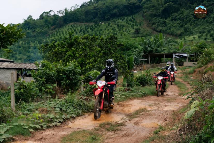
Major transport hubs like Ha Giang City, Dong Van, and Meo Vac feature much heavier congestion due to local commuters, tourist fleets, and large commercial trucks. These urban zones require maximum defensive awareness as scooters dart out of busy side streets and delivery vans pull over abruptly. In sharp contrast, the open rural segments offer significantly lower vehicle volumes, meaning the Ha Giang loop road conditions here introduce unique hazards like stray livestock blocking your path around blind curves.
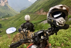
Ha Giang loop road conditions vary significantly
1.2. Identifying high-activity and congested zones
Bustling local market centers and crowded scenic hotspots like the world-famous Ma Pi Leng Pass see sudden surges of slow-moving tour buses and parked mini-vans. Understanding these high-activity zones allows you to time your transit safely, as daily traffic levels fluctuate predictably across the province. Planning your rides around midday offers significantly quieter mountain roads, modifying the baseline Ha Giang loop road conditions compared to the highly congested morning and late afternoon periods.
1.3. Typical obstacles and sharing the road with diverse users
Safety and awareness are essential throughout any Ha Giang Loop motorbike tour, as riders share the roads with a variety of vehicles and local traffic. Along the route, you may encounter trucks, buses, motorcycles, farm vehicles, and occasional livestock crossing the road near rural communities. Maintaining a steady pace, staying alert to changing conditions, and anticipating unexpected obstacles will help ensure a safer and more enjoyable journey through the spectacular landscapes of Ha Giang.
2. Environmental impacts on Ha Giang loop road conditions
The weather patterns of Ha Giang are incredibly volatile, acting as the primary force that alters the physical state of the pavement. A route that feels smooth and predictable in the morning can quickly transform into a highly technical test of traction by afternoon. Managing changing environmental factors is critical because seasonal shifts dictate the daily safety level of the asphalt. Let us explore how the intense summer rainy season, the dusty winter dry season, and public holiday surges interact with the regional Ha Giang loop road conditions.
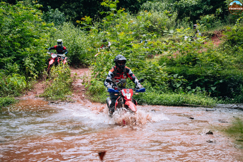
2.1. Crucial hazards during the rainy season (May to September)
Weather conditions can have a major impact on the riding experience during a Ha Giang Loop motorbike tour, particularly throughout the rainy season. Heavy rainfall may create slippery road surfaces and occasionally affect travel conditions in mountainous areas, while low clouds and fog can reduce visibility on higher passes. For this reason, checking weather forecasts and local road updates before each riding day is strongly recommended to ensure a safer and more comfortable journey.
Monsoon rains create dangerous mountain roads
2.2. Driving environment during the dry season (October to April)
The cooler dry season offers a generally more stable, much safer, and clearer driving environment, making it the preferred travel window for international motorcyclists. However, this period introduces its own specific dry-weather challenges, such as deep pockets of accumulated dust and thick layers of loose gravel. These loose surface textures require smooth throttle inputs, modifying the local Ha Giang loop road conditions, particularly when navigating the unpaved off-road trails branching into the valleys.
2.3. Strategic timing for a smooth and reduced-crowd journey
Major Vietnamese public holidays cause immediate traffic surges, packing prominent mountain towns with domestic travelers and local holiday crowds. To avoid these dense bottlenecks, we highly recommend scheduling your tour during weekdays or choosing the beautiful shoulder seasons from September to November and March to April. Navigating the Ha Giang loop road conditions during these quieter months ensures you enjoy stable weather, pleasant scenery, and completely uncrowded viewpoints.
3. Classification of route types and surface textures
The infrastructure network crossing the Dong Van Karst Plateau is a complex patchwork of varying engineering standards. Riders must abandon the expectation of uniform highway surfaces, as the trail transitions rapidly between completely different technical styles. The variation in terrain directly affects your motorcycle's stability, braking distances, and overall chassis handling. Let us break down the diverse surface textures you will encounter, from the primary highway arteries to the rugged wilderness tracks.
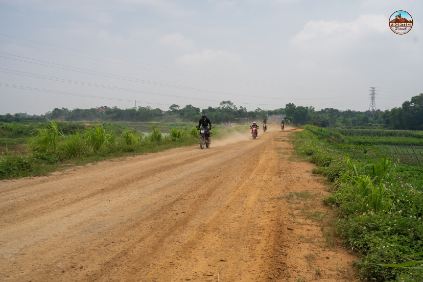
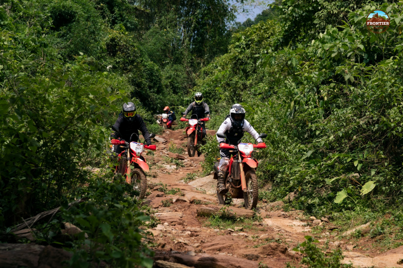
3.1. General terrain features and surface diversity
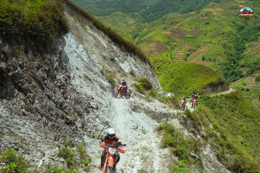
Travelers on this circuit will encounter a wide range of track surfaces that transition from fresh, well-paved asphalt to uneven stone terrain, deep potholes, and broken tarmac. These rapid structural changes mean that the Ha Giang loop road conditions require riders to constantly adapt their speeds and cornering techniques. Approaching active road construction zones with extreme caution is vital, as loose gravel frequently scatters across sharp mountain bends.
Rough mountain terrain demands constant adaptation
3.2. Characteristics of the main highway circuit (QL4C)
The QL4C serves as the primary highway infrastructure for the region, handling the bulk of the commercial and tourism traffic flow. This main artery offers a more predictable, better-maintained surface texture, making it highly suitable for riders with standard motorcycle touring experience. While it still features immense elevation changes and sharp turns, its structural consistency provides a reliable baseline for your multi-day itinerary.
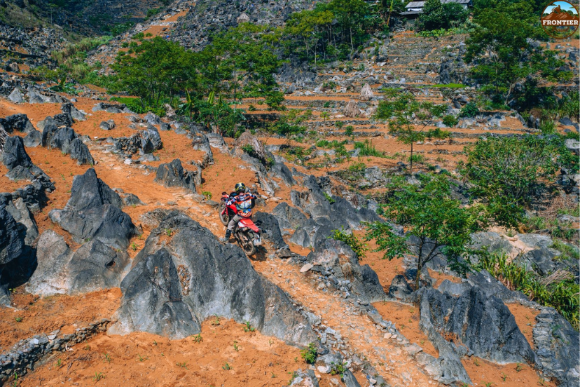
3.3. Challenging off-road paths for experienced riders
For highly capable operators, the rugged, unpaved side trails branching off the QL4C offer lower traffic volumes but significantly higher technical difficulty. These adventurous paths feature steep gradients, deep ruts, loose river rocks, and muddy river crossings that will test the limits of your machine's suspension. Tackling these remote wilderness tracks demands advanced motorcycle handling skills, excellent physical stamina, and a thoroughly prepared dual-sport bike.
4. Crucial guidelines for handling mountainous terrain
Conquering the vertical landscape of the northern border requires specialized alpine riding techniques that differ from standard flatland cruising. The sheer scale of the limestone passes leaves no room for careless lane positioning or late braking decisions. Developing a systematic approach to handling steep inclines and blind corners is the most effective way to keep your journey smooth. Let us examine the proper line selections, visual focus strategies, and infrastructure hazards that define the regional driving experience.
4.1. Managing steep inclines and blind curves safely
The inherent dangers of this extreme topography are defined by hundreds of consecutive sharp bends, steep vertical gradients, and frequent blind mountain corners. To manage these hazards safely, you must lower your entry speed significantly prior to initiating any turn and maintain a conservative lane position. Briefly sounding your vehicle's horn before entering tight curves is a crucial local habit that effectively alerts oncoming traffic to your presence.
Steep curves require cautious driving control
4.2. Proper cornering techniques for tight mountain passes
To maintain total stability through intense switchbacks, you must train your eyes to look far ahead through the curve rather than directly down at the front tire. Lean your body naturally with the motorcycle while maintaining a steady chassis balance through smooth, controlled application of the throttle and brakes. Managing your momentum correctly prevents the bike from drifting wide into the oncoming lane where heavy utility trucks might be descending.
4.3. Dealing with ongoing infrastructure projects and roadworks
Continuous road maintenance and massive highway expansion projects take place across the province year-round to improve the overall Ha Giang loop road conditions. These active construction zones can lead to sudden, unannounced route detours, single-lane alternating traffic bottlenecks, or temporary road closures. Always consult with your local accommodation hosts or motorcycle rental shops each morning to gather accurate field intelligence regarding active delays.
5. Pre-trip vehicle inspections and essential safety equipment
When operating a motorcycle in a remote border region, your personal protective equipment and mechanical reliability serve as your primary survival lines. A failure to prepare your gear properly can turn a minor slip on loose gravel into a trip-ending logistical crisis. Ensuring total compliance with local traffic laws and equipping yourself with high-visibility gear is essential before turning your key. Let us look at the mandatory safety apparel and legal documentation required to navigate the mountain checkpoints smoothly.
5.1. Mandatory protective gear for motorbike riders
Conquering the unpredictable Ha Giang loop road conditions safely requires a strict commitment to high-quality helmets, padded riding jackets, reinforced long pants, and sturdy gloves. Wearing proper protective boots is also essential to safeguard your feet and ankles from impacts with loose stones or minor trail drops. Additionally, using bright reflective vests and auxiliary LED lights will dramatically enhance your visibility to other motorists during thick alpine fog.

Protective gear ensures safe mountain riding
5.2. Legal compliance and adapting to local traffic regulations
Adhering strictly to posted speed limits, following international traffic signs, and understanding rural driving habits are critical components of a safe tour. International travelers must carry a valid original passport, an appropriate visa, and a recognized national driving license to ensure smooth interactions at municipal checkpoints. Respecting these local legal frameworks prevents stressful administrative delays and ensures your travel insurance policy remains fully valid.
6. Digital navigation strategies for remote Ha Giang loop road conditions
The deep stone canyons and high ridges of the far north present a unique challenge for standard modern communications systems. Relying blindly on real-time cellular data to guide your motorcycle through these remote border districts is a dangerous logistical mistake. Developing a robust digital backup strategy ensures you can navigate route shifts and weather closures without losing your bearings. Let us explore how to manage patchy signals, utilize offline mapping tools, and select a motorcycle hull that complements the regional geography.
6.1. Overcoming patchy mobile signal in the highlands
The cellular networks and mobile data infrastructure in these remote, high-altitude mountain sectors can be highly unreliable or completely nonexistent. To prevent getting lost when your network connection drops, you must avoid relying on live streaming data for your primary navigation needs. Utilizing onboard GPS tracking remains highly effective, provided you couple it with specialized applications built for standalone offline operations.
6.2. Utilizing offline maps for real-time route adjustments
Pre-downloading highly detailed offline mapping files via Google Maps or Maps.me acts as a vital navigational lifeline when cellular service disappears completely. These digital maps allow you to quickly calculate alternative valley paths when encountering unexpected road blockages, heavy landslides, or construction detours. Having instant access to offline terrain data keeps your itinerary on track, even when the volatile Ha Giang loop road conditions force a sudden change of plans.
Offline maps help navigate mountain routes
6.3. Selecting the correct motorcycle for the terrain
Matching your rental vehicle to your actual personal skill level and the expected trail surfaces is vital for your overall safety and comfort. Choosing a reliable, well-suited motorcycle with excellent ground clearance and robust brakes is the ultimate secret to successfully mastering both the paved highways and the unpaved paths. Our fleet is meticulously maintained to ensure your machine responds perfectly to every single challenge the mountain throws your way.
7. Frequently asked questions regarding the journey
Navigating a high-altitude motorcycle circuit naturally brings up several practical questions regarding safety windows, checkpoint logistics, and crisis management on the road. When planning your custom northern crossing, having clear operational data helps eliminate any pre-trip anxiety for your group. Let us address the most common inquiries received by our team to help you prepare your packing list and route timing with total confidence.
7.1. When is the safest and most ideal time to ride the loop?
The dry winter season from October to April offers the most stable, clear, and safe driving environment across the northern province. For the absolute best experience, aim for the shoulder periods of September to November or March to April to enjoy pleasant weather and manageable traffic levels. These specific monthly windows allow you to experience the magnificent landscape without dealing with the heavy mud hazards of the summer monsoon.
7.2. What legal documents and identification are required for checkpoints?
International motorcyclists must carry their original physical passport and valid visa documentation at all times throughout the multi-day mountain journey. You are also legally required to hold a valid national driving license that complies with Vietnamese transport regulations to clear regional border checkpoints. Keeping these original documents organized inside a easily accessible, 100% waterproof pouch protects them from sudden rainfall and dust.
Carry documents for smooth checkpoint access
7.3. How should riders prepare for sudden changes in weather and roads?
Riders must pre-download offline navigation maps to handle sudden mobile signal losses and quickly identify alternative routes around active construction detours. It is equally important to equip your group with high-visibility reflective vests and bright LED lights to maintain safety during low-visibility fog conditions. Always check the latest local traffic updates and weather patterns each morning before firing up your motorcycle engine.
8. Conclusion
Mastering the challenges of the mountainous terrain is the key to an incredible northern adventure. Being fully prepared for the changing Ha Giang loop road conditions allows you to focus entirely on the breathtaking scenery. Please contact Frontier Travel Vietnam immediately to learn more about our premium travel services and start planning your dream trip today.