No matter how many travel stories you read, nothing truly prepares you for the jaw-dropping visual scale of a Ha Giang loop guide photos. Words simply fall short when describing the sheer verticality of the limestone karsts, the dramatic M-shaped hairpins, and the emerald ribbon of the Nho Que River cutting through Southeast Asia’s deepest canyon. To truly master the light and frame these untamed frontiers, booking an extended multi-day expedition with Frontier Travel Vietnam is the absolute best choice.
1. Introduction: Framing the Best Ha Giang loop guide photos
The northernmost province of Vietnam represents a geographical anomalies zone where massive tectonic forces have carved an incomparable alpine landscape. For visual creators, Ha Giang Loop Motorbike Tour provides an endless array of sharp contrasts, deep textures, and dramatic lighting conditions that change by the minute. Navigating these remote mountain roads with a camera requires a distinct operational approach compared to standard holiday photography.
Authentic Ha Giang loop guide photos preserve rare cultural encounters
1.1. Why Ha Giang is a Photographer’s Paradise
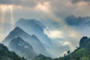
Colossal limestone karsts create unparalleled geometric background structures. The primary allure of the region stems from the sheer scale of the Dong Van Karst Geopark. Vertically stacked limestone towers rise up to 1,400 meters above sea level, casting immense shadows across deep agricultural valleys.
This harsh gray stone landscape contrasts beautifully with the vivid hand-woven indigo and fuchsia garments worn by local H’mong, Dao, and Tay communities. Capturing these human elements against an ancient monochromatic backdrop creates powerful Ha Giang loop guide photos that tell stories of resilience.
While the natural scenery is undeniably breathtaking, success as a visual creator depends on how much time you allocate to the journey. Rushing through the roads can result in missed moments and compromised frames under poor atmospheric conditions.
1.2. The Importance of Slow Travel for Great Photography
Midday solar glare washes out delicate mountain valley details. Attempting to document this vast landscape on a compressed two-day commercial itinerary is a recipe for photographic failure. Fast-paced tours force riders to travel through the most spectacular passes during the middle of the day, when harsh, vertical sunlight washes out all structural definitions.
A premium, extended motorcycle expedition gives creators the necessary flexibility to wait for optimal lighting transitions. Taking a slow, calculated approach ensures you are perfectly positioned on high ridges when the low-lying alpine mist settles perfectly between the jagged peaks.
2. Equipment Checklist: What to Pack for the Best Ha Giang Loop Photos
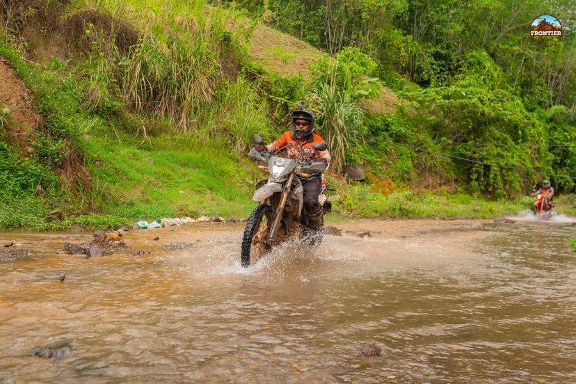
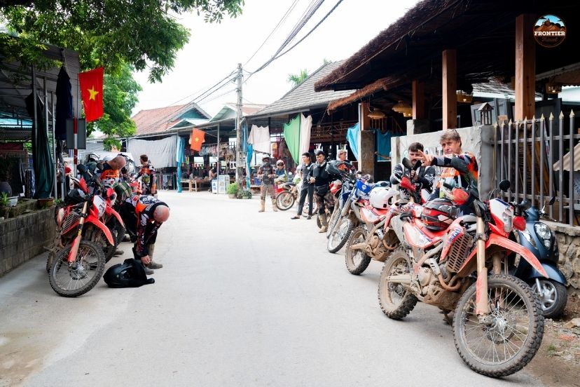
Operating camera equipment during a motorcycle journey exposes it to fine limestone dust, sudden rain, and constant vibration from uneven mountain roads. Protecting each device while keeping it accessible requires practical storage and mounting solutions suited to long-distance riding.
2.1. Camera Gear and Protection
Versatile wide-zoom optics capture expansive mountain horizons and layered valley views. A reliable photography kit should combine the broad perspective of an ultra-wide zoom lens with the storytelling detail of a fast prime lens. We recommend packing a weather-sealed 16–35mm lens for sweeping landscapes, together with a 50mm or 85mm portrait lens for respectful cultural photography.
This combination helps create diverse Ha Giang loop guide photos, from dramatic mountain panoramas to expressive local portraits. Your equipment should remain protected inside a heavy-duty waterproof dry bag secured firmly to the motorcycle rack. A padded camera insert or vibration-reducing storage case also helps protect sensitive lenses and stabilization systems throughout long rides on rough roads.
Alongside handheld camera gear, a GoPro or another compact action camera is ideal for capturing dynamic riding perspectives, winding mountain roads, and memorable moments without requiring frequent stops.
2.2. GoPro and Action Camera Logistics
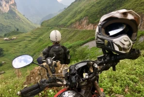
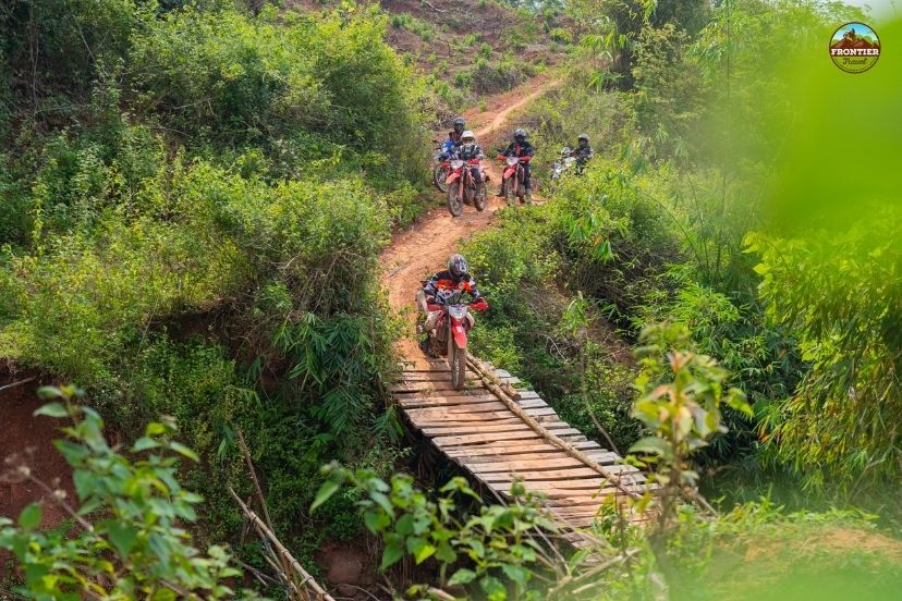
A securely mounted GoPro or action camera captures immersive first-person views throughout the Ha Giang Loop Motorbike Tour. Riders can position the device on a helmet chin mount, chest mount, or stable handlebar mount to record dramatic mountain passes, steep valley roads, and tight switchbacks from a natural riding perspective.
High-frame-rate recording is especially useful for documenting movement on uneven roads and creating smooth footage of scenic riding sections. Because these compact cameras are lightweight and easy to operate, they allow riders to focus on the journey while still preserving authentic visual highlights along the route.
Before departure, riders should check battery levels, memory card capacity, waterproof housing, and mount stability. Carrying spare batteries or a portable power bank is recommended for long riding days, ensuring the GoPro or action camera remains ready to capture the most impressive moments of the Ha Giang Loop.
Vibrations require protective camera cases
3. Geographic Breakdown: Iconic Viewpoints and Photo Stops
The northern loop contains multiple world-famous overlooks that require precise timing to yield professional-grade visual assets. Each district features a unique geological profile, shifting from soft, terraced agricultural hills to sheer, vertical canyon walls.
3.1. The Gateway: Quan Ba and Yen Minh Districts
Entering the mountain highlands requires an immediate adjustment to your composition style as the horizon expands dramatically. Let us look at the first two major landmarks that define the entrance to this alpine world.
3.1.1. The Quan Ba Heaven’s Gate Viewpoint
Sunrise mountain gaps yield spectacular multi-layered atmospheric compositions. The first major elevation shift occurs as the road scales a steep mountain gap located exactly 43 kilometers north of the city center. At this summit, an old stone lookout platform provides a sweeping panoramic perspective of the ribbon-like highway winding down into the misty valley below.
To capture this scene effectively, operators should employ a circular polarizing filter to slice through the heavy atmospheric haze. The optimal shooting window opens between 07:00 AM and 08:30 AM, when the rising sun casts long, directional shadows across the distant pine forests.
As you descend past the misty mountain gaps, the terrain flattens out slightly into a vibrant valley floor. This transition reveals an incredible geological anomaly that serves as a perfect subject for testing your telephoto lenses.
3.1.2. The Twin Mountains (Co Tien Mountain)
Symmetrical geological hills contrast beautifully with flat agricultural base plains. Rising directly from the flat alluvial floor of the Tam Son valley are two perfectly symmetrical, conical limestone hills that have inspired regional folklore for centuries. Capturing this unique landform for memorable Ha Giang loop guide photos requires a medium telephoto focal length to compress the architectural layers of the surrounding ethnic villages.
Photographers should frame the hills against the shifting seasonal colors of the agricultural fields below. Whether the plains are flooded with water or glowing with golden rice, the resulting images offer an exceptional look at local geographic harmony.

Smart planning improves Ha Giang loop guide photos opportunities
3.2. The Heart of the Karst: Dong Van Plateau
The massive stone fortress of the northern plateau demands high contrast lighting and strong geometric framing. This sector features the most celebrated roadway switchbacks and architectural gems on your entire Ha Giang loop guide photos track.
3.2.1. Conquering the Legendary Tham Ma Pass
Elevated summit lookouts reveal the complete geometric profile of hairpin turns. This legendary nine-turn zigzag pass serves as the definitive visual symbol of adventure travel in Northern Vietnam. To capture the full geometric beauty of these sweeping hairpins, photographers must hike up to a natural rock ledge located just above the upper parking area.
Utilizing a wide-angle lens allows you to frame oncoming motorcycle convoys as they lean into the sharp, uniform curves below. A Ha Giang loop guide photos session is incomplete without this classic shot, which highlights the true scale of human engineering slicing through the mountains.
3.2.2. The Historic H'Mong King’s Palace (Dinh Vua Meo)
Moody interior courtyards preserve century-old French imperial wood carvings. Located within the quiet valley of Sa Phin, this century-old architectural gem offers a dramatic shift from expansive landscapes to moody, intimate structural photography. The fortress features a unique blend of traditional Qing Dynasty stone work, French colonial iron bars, and indigenous H'Mong wood carvings.
Creators should focus on the soft, diffused light filtering into the moss-covered inner courtyards, highlighting the aged textures of the ancient pine pillars. Utilizing a fast prime lens with an aperture of f/1.8 helps isolate these intricate historical details against the dark stone walls.
3.3. The Pinnacle: Meo Vac and the Ma Pi Leng Pass
The boundary line between Dong Van and Meo Vac contains the most visually explosive terrain in Southeast Asia. Let us explore how to safely frame these monumental vertical cliffs from both elevated ridges and low-angle water levels.
3.3.1. The Ma Pi Leng Skywalk Rim
Precipitous cliff ledges frame tiny rider silhouettes against deep canyons. This incredible stretch of road clings tightly to sheer vertical cliff faces that drop 1,000 meters directly into the river canyon below. To capture the true scale of the pass in dramatic Ha Giang loop guide photos, photographers should safely walk along the old suspension path known as the Skywalk rim.
From this elevated vantage point, a standard 24mm lens can frame a single motorcycle rider as a tiny silhouette against massive mountain walls. During late afternoon golden hour, the jagged peaks glow in warm orange tones while the deep canyon floor fades into rich blue shadows.
3.3.2. The Turquoise Nho Que River Cruise
Towering vertical walls dominate frames from low angle water viewpoints. Transitioning from the high mountain ridges down to the actual water level reveals an entirely new perspective on the Tu San Canyon. Boarding a small watercraft allows photographers to look straight up at the towering vertical cliffs that form the deepest gorge in Southeast Asia.
This low-angle view requires an ultra-wide lens to capture both the turquoise water surface and the distant sky framing the cliff tops. The towering canyon walls naturally block direct sunlight, creating beautifully soft, evenly distributed lighting conditions that are perfect for capturing rich color saturations.
4. Seasonal Photography Guide: When to Capture the Best Colors
The visual character of the northern frontier changes completely over the course of four distinct seasonal phases. Each cycle introduces a completely new color scheme to the landscape, altering how creators approach exposure values and white balance settings. Understanding these transformations allows you to align your journey with the specific visual style you want to achieve for your portfolio.
4.1. Spring (January to March)
Soft pastel blossoms bring delicate organic textures to gray stone homes. Early spring introduces an ethereal, romantic atmosphere to the rugged karst landscape as thousands of local trees bloom simultaneously. The delicate pink hues of peach blossoms and the clean whites of plum trees contrast beautifully with the dark, weathered stone of the traditional homesteads.
Photographers should leverage these soft organic textures to frame environmental portraits of the local ethnic communities. The soft, diffused light caused by the persistent morning mist creates low-contrast scenes that preserve subtle details across your frames.
4.2. Summer (May to August)
Flooded agricultural steps create vast natural mirrors reflecting mountain skies. Summer unleashes a wave of intense energy across the northern provinces as heavy tropical downpours feed the local waterways. In May and June, the region enters the "Water Pouring Season," during which the vast stepped agricultural terraces are completely flooded by mountain streams.
These watery steps act as giant natural mirrors that reflect the dramatic summer storm clouds moving across the sky. The surrounding stone plateaus are covered in deep, vibrant green corn crops, providing rich color saturation that looks spectacular when captured with a polarizing filter on your Ha Giang loop guide photos tour.
Shifting seasonal color palettes dictate specific camera exposure parameters
4.3. Autumn (September to October)
Brilliant yellow rice terraces create immense golden waves down valleys. This short window is widely considered the absolute pinnacle for landscape photography due to the ripening of the rice crops. The endless terraced valleys of Hoang Su Phi transform into brilliant waves of golden yellow that cascade down the steep mountain slopes.
The autumn skies remain exceptionally clear and blue, providing high-contrast conditions that enhance the sharpness of your landscape shots. Photographers should utilize a telephoto zoom lens to isolate the complex geometric patterns formed by the curving agricultural steps.
4.4. Winter (October to December)
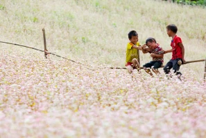
Delicate pink buckwheat flower blankets soften the rugged mountain ridges. As the cold winter winds arrive, the high-altitude fields are covered in vast blankets of pink and purple buckwheat flowers. These delicate blossoms are intentionally planted by local farmers on the steep slopes, creating a beautiful contrast against the sharp limestone needles.
The low winter sun sits at a sharp angle throughout the day, casting long, dramatic shadows that add excellent depth to wide landscape frames. This season offers a raw, moody look at the frontier, perfect for creating powerful, atmospheric black-and-white compositions on your Ha Giang loop guide photos run.
5. FAQs: Ha Giang Photography Tour
Planning a dedicated documentary expedition through extreme mountain terrain requires clear answers regarding equipment safety and local regulations. Our professional media team has compiled answers to the most common questions asked by incoming camera operators.
Can I bring a full-frame DSLR and three lenses?
Yes, absolutely. You can comfortably carry your primary camera body and a versatile walk-around lens in a small backpack while riding. Your remaining heavy gear, telephoto lenses, stable tripods, and hard storage cases can be stored safely inside the Frontier support vehicle, protecting them from dust, continuous vibration, and sudden mountain rain.
Professional support vehicle fleets secure heavy tripods and hard cases
5.1. Are drones legal in Ha Giang?
Yes, but with strict geographical restrictions. While drone photography is highly rewarding due to the massive landscape scale, the region sits on a sensitive international border zone. Flying is generally safe in established tourist hubs like Ma Pi Leng or Tham Ma, but you must strictly avoid operating your aircraft near military outposts, government facilities, or the actual Chinese border line on a Ha Giang loop guide photos expedition.
5.2. Will there be time for sunrise and sunset shoots?
Yes, our specialized itineraries are explicitly timed around the golden hours. Unlike rushed commercial convoys that speed through the passes to hit distant hotels, we launch early to capture misty sunrises at Quan Ba. We also schedule afternoon arrivals at iconic passes just as the warm sunset light hits the canyon walls for perfect Ha Giang loop guide photos assets.
5.3. Can I skip riding to focus entirely on photography?
Yes, and this is highly recommended for serious content creators. You can book our professional Easy Rider service or secure a comfortable window seat inside our tracking support vehicle. This frees your hands and mental focus from the technical demands of the hairpins, allowing you to safely scout locations and produce Ha Giang loop guide photos masterpieces while on the move.
5.4. Is there WiFi to backup photos?
Yes, but connection drops completely while driving through deep canyons or high-altitude passes. Reliable, high-speed WiFi networks are available at every single overnight hotel and town homestay for backing up your daily shoots to cloud storage. However, we strongly advise bringing plenty of physical SD cards and external SSDs to ensure a reliable offline backup solution.
6. Conclusion
Ha Giang loop guide photos portfolios cannot reach their full professional potential if you rush through these magnificent northern landscapes on a tight, compressed schedule. By leaving the complex frontier permits, dual-sport fleet maintenance, and route pacing to our specialized crew, you free up your creative energy to compose truly world-class imagery. Secure your elite photography expedition with Frontier Travel Vietnam today to unlock exclusive access to the most spectacular, hidden mountain viewpoints on the edge of the frontier.